
Description
Cadmap Ltd: The Premier Land, Building & Utility Surveyors in Wimbledon, London
Tucked within the charming Wimbledon suburb at Office 9, Dalton House, 60 Windsor Avenue, Cadmap Ltd stands as a beacon of accuracy and professionalism in surveying. Established in 2011, this fully accredited firm specializes in measured building surveys, topographical land surveys, and PAS 128-compliant underground utility and CCTV drainage assessments. With over 30 years of accumulated team experience, Cadmap delivers reliable, tech-driven outcomes for developers, architects, and civil engineers across London and the South East.
From its earliest days, Cadmap Ltd has built a strong reputation by combining traditional surveying values with the most modern digital tools and techniques. Clients ranging from property developers to heritage consultants rely on Cadmap’s detailed data outputs to make informed design and construction decisions. Their work underpins many of London’s most complex developments, ensuring that foundational knowledge—of ground conditions, building layouts, and subterranean infrastructure—is delivered accurately and on time.
The firm’s strategic Wimbledon base positions them perfectly to serve a broad swath of Southern England. Their ability to deploy teams swiftly across Greater London, Brighton, Southampton, and Surrey means they’re trusted not just for precision, but also for responsiveness. Cadmap isn’t just about maps and measurements—they’re about helping build better, safer, and more efficient spaces across the region.
Exceptional Services & Technical Excellence
Measured Building Surveys & Topographical Mapping
Cadmap excels in producing detailed surveys tailored for listed buildings, architectural refurbishments, and planning projects. With laser scanners and robotic total stations, their drawings—floor plans, sections, and elevations—offer precise, reliable representations for design teams.
Their measured surveys are more than just technical drawings—they’re indispensable tools that enable clients to visualize every inch of a structure before lifting a single hammer. Whether it’s a historical townhouse in Kensington or a commercial warehouse in Croydon, Cadmap’s surveyors capture every detail with millimetre-level accuracy. These measured drawings help architects avoid costly on-site surprises and ensure planning authorities receive dependable documentation.
Topographical surveys, meanwhile, are key to unlocking land potential. Using GNSS and total stations, Cadmap charts terrain elevations, manholes, trees, boundaries, and more. This bird’s-eye view of existing conditions allows landscape architects and developers to understand land constraints, plan drainage, and optimize site layouts from the outset. Cadmap’s ability to produce topographic data in CAD and Revit formats gives clients immediate usability.
PAS 128 Utility & GPR Surveys
Pas128-certified, Cadmap’s GPR (Ground Penetrating Radar) surveys pinpoint underground utilities, including drains, cables, and gas lines—critical groundwork for safe excavation. Their step-by-step utility mapping follows BSI standards rigorously, ensuring developers avoid costly surprises underground.
These surveys are not just compliance exercises; they are vital for risk reduction. A burst main or severed fibre optic cable can derail a project and incur substantial costs. Cadmap’s PAS 128 methodology offers various survey levels—from desktop records search (Type D) to full detection, verification, and location (Type B). This layered approach tailors insights to project needs, offering both affordability and comprehensiveness.
Their use of IDS Stream and Mala Easy Locator Pro tools means utility positions are not just estimated, but captured with high accuracy and confidence levels. Combined with color-coded CAD outputs and utility conflict analysis, Cadmap’s deliverables make site excavation vastly safer. Contractors and engineers consistently report fewer interruptions and faster build timelines when Cadmap surveys are on file.
CCTV Drainage & 3D Visualisation
Beyond land and utility work, the firm offers CCTV drain inspections—recording depths, structural condition, and flow data. Their 3D visualisations and BIM-ready models support complex planning and heritage restoration projects.
Using push rod cameras and crawler systems, Cadmap’s drainage teams inspect and diagnose below-ground issues that often go unnoticed. These inspections identify root ingress, pipe fractures, blockages, and silt buildup—conditions that can affect planning applications or delay renovations. High-resolution video footage and detailed defect coding enable civil engineers to specify targeted repairs with clarity.
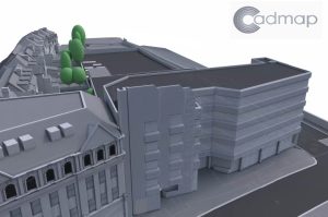
In parallel, Cadmap’s 3D modelling capabilities bring built environments to life. By transforming raw scan data into digital twins, they enable stakeholders to assess as-built conditions virtually. These models are used for clash detection, floor planning, and design visualisation in both AutoCAD and Revit platforms. Especially for listed buildings or congested urban sites, their models streamline planning approval processes and coordination among trades.
What Clients Say
Cadmap’s reputation shines through glowing client feedback:
- “Highly recommend!” shared a client using Cadmap for both measured building and land surveys across London.
- Another praised their efficiency and friendly service: “We chose CAD Map to have our building survey and found them to be very efficient and friendly.”
- One review stated: “Thoroughly impressed since the moment we brought them onboard” for land surveying work.
These testimonials reflect Cadmap’s professionalism, collaborative spirit, and ability to exceed expectations.
Additional reviews frequently mention quick turnaround times, easy communication, and value for money. Clients also appreciate Cadmap’s willingness to go above and beyond—whether it’s producing extra cross-sections at short notice or providing helpful explanations of technical data. This attention to detail and client care sets Cadmap apart in an industry that can often feel impersonal or purely transactional.
It’s not just homeowners or developers offering praise—many architectural and construction firms list Cadmap as their preferred surveying partner. Their ability to work collaboratively, deliver on tight schedules, and maintain exceptional quality has helped foster long-term business relationships and repeat work across London’s competitive built environment sector.
Deep Community Roots & Team Passion
Operating across London, Surrey, Sussex and beyond, Cadmap is deeply embedded in the regional construction landscape. Their Wimbledon location allows easy access to both central London and suburban sites. Similarly, offices in Brighton, Southampton, and Surrey demonstrate strategic regional presence.
This wide geographic footprint reflects Cadmap’s commitment to staying close to their clients and job sites. Surveyors regularly attend locations from early morning to late afternoon, adjusting schedules around client needs and project milestones. Their local presence means they understand borough-specific planning requirements and underground infrastructure patterns—crucial knowledge in areas with aging utilities or conservation rules.
Though we didn’t conduct a direct interview, LinkedIn updates from owner Michael Brett and senior staff reflect a team that combines technical precision with hands-on fieldwork—whether scanning heritage pubs or unmapped utility grids. These posts depict Cadmap as a community-driven, responsive business.
The company also participates in local CPD events and technical forums, demonstrating a commitment to industry learning and sharing best practices. Through these engagements, they contribute to raising standards in the surveying field while keeping their own methods up to date. Their team culture emphasizes mentorship, professional growth, and pride in delivering data that drives the built environment forward.
Why Cadmap Stands Out
- Technological Edge – Their Leica laser scanners, robotic total stations, Zeb Revo RT systems, and IDS/GPR devices highlight Cadmap’s investment in accuracy.
- Full-Spectrum Surveying – Covering everything from land and building to utilities and drainage, clients can count on a one-stop solution.
- Trusted & Accredited – PAS 128 and TSA-approved credentials, plus glowing client testimonials, showcase Cadmap’s reliability.
- Client-Focused Culture – Reviews highlight efficiency, approachability, and a can-do attitude—traits rare in technical services.
This combination of cutting-edge equipment and responsive client service makes Cadmap a true standout in their sector. They’re not the biggest surveying firm—but their agility and expertise allow them to outperform larger competitors on quality, accuracy, and service.
By offering a full suite of interrelated survey services under one roof, Cadmap simplifies project coordination. Clients don’t need to juggle multiple subcontractors or worry about data gaps—everything flows from a single, well-organized source. Their quality assurance systems ensure every output meets internal and industry standards before reaching the client.
Ultimately, Cadmap’s team is the key to their success. From technicians to directors, every employee is focused on problem-solving, precision, and delivering exactly what the client needs to move forward with confidence. This people-first approach is evident in every interaction, from quote to completion.
Cadmap Ltd is more than a surveyor—they’re a trusted partner ensuring construction and planning projects begin with integrity and clarity. Their tech proficiency, wide-ranging services, and dedication to customer satisfaction make them a standout choice for anyone in London and the South East.
Whether you’re an architect needing detailed measured plans, a developer preparing a site, or a planner mapping utilities, Cadmap’s expertise delivers peace of mind and precision. Choose Cadmap Ltd for your next project—accurate, accredited, and always client-first.
Their proven track record, stellar client feedback, and industry certifications are just the beginning. Behind each scan, map, or model is a team genuinely invested in the success of your project. From back gardens to building redevelopments, Cadmap Ltd supports construction excellence—one survey at a time.


